Social indicators
| Population growth rate (average annual %) | 1 (2023, World Bank) |
| Urban population growth (annual %) | 2.9 (2023, World Bank) |
| Rural population growth rate (average annual %) | -0.2(2023, World Bank) |
| Urban population (%) | 40 (2023, World Bank) |
| Population aged 0-14 years (%) | 26 (2023, World Bank) |
| Education: Primary-secondary gross enrolment ratio (f/m per 100) | 1.14 (2021, World Bank) |
| Sex ratio at birth (male births per female births) | 1 (2022, World Bank) |
| Life expectancy at birth (females and males, years) | 74 (2022, World Bank) |
| Infant mortality rate (per 1,000 live births) | 24 (2022, World Bank) |
| Fertility rate, total (births per woman) | 1.9 (2022, World Bank) |
Economic Indicators
| GDP per capita (US$) | 2,529.1 (2023, World Bank) |
| GDP growth rate | 5.8 (2023, World Bank) |
| Adjusted net national income (current US$) (Millions) | 430,454.77 (2021, World Bank) |
| GNI per capita, Atlas method (current US$) | 2,860 (2023, World Bank) |

Bangladesh, east of India on the Bay of Bengal, is South Asian country of lush greenery and many waterways. Its Padma (Ganges), Meghna and Jamuna rivers create fertile alluvial plains, and travel by boat is common. On the southern coast, the Sundarbans, an enormous mangrove forest shared with India, are home to the Royal Bengal tiger.
Bangladesh is a member of SACEP since 1985 and Mr. A. M. S. Haque (1988 - 1991) and Dr. Md Masumur Rahman (2021-2023) served as the Third and forteenth Director General of SACEP respectively.
Country’s Environmental Profile
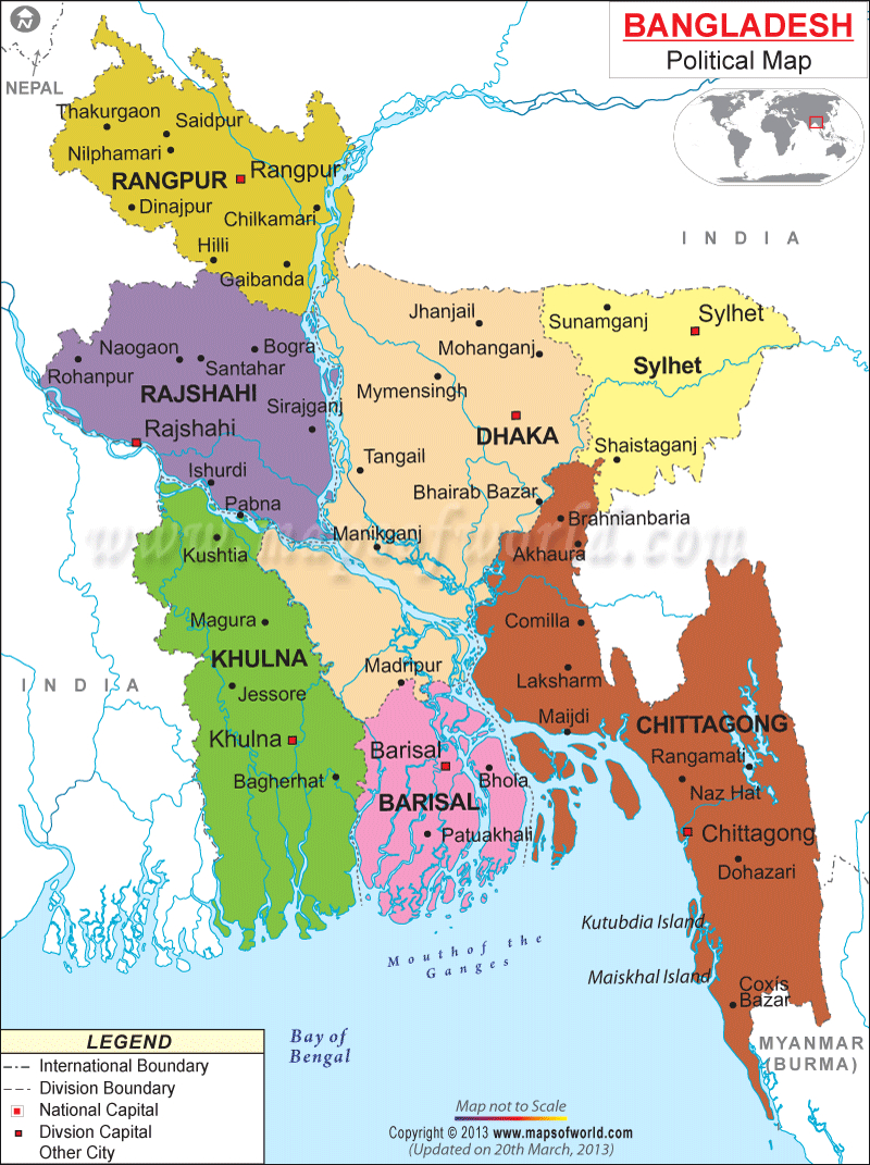
Bangladesh is surrounded by India in the West, North and Northeast and by Myanmar on the Southeast with the Bay of Bengal in the South providing a gateway to the oceans of the world. It enjoys the sub-tropical monsoon climate regime characterized by high temperatures, heavy rainfall and excessive humidity with marked seasonal variations.
The Country is endowed with a unique natural resource base. About 80% of the country consists of floodplains and wetlands with over 300 rivers in the riverine network that sustains rare wildlife, flora and fauna. There are diverse ecological systems in the country ranging from the unique mangrove forests of the SundarbansSundarbans www.sunderbans-national-park.com/ in the Southwest to coastal and marine ecosystems in the deep South; deep natural water basins called “haors’ and “baors” https://en.wikipedia.org/wiki/Haor in the Northeast which remain inundated for half of the year and has a unique but changing ecology; arid area in the upper mid-section to hill tracts in the Southeast and flat sandy or marshy riverine deltas in the middle down to South.
The country has more than 700 kms of coastline in the South along the bay of Bengal with a population of over 35 million who are most vulnerable to cyclones, tidal surges and salinity ingress. Coastal Estuaries and wetlands are rich in fisheries and other biodiversity resources.
Bangladesh has limited natural forest cover, at about 10 percent of land area, down from 20 percent in the 1960s, and almost all of that area is now seriously degraded, as a result of extreme population pressure for fuel wood and other forest products. Major Forest types found in the country are Tropical Green forests, Semi evergreen forest, Deciduous Forests, Mangroves forests and homestead forests.
The country supports good floral and faunal biodiversity which includes 4,061 species of vascular plants, 653 species of fishes, 34 species of amphibians, 154 species of reptiles,650 species of birds,121 species of mammals. Among them are some of the internationally significance species such as Asian Elephant, Royal Bengal Tiger, Gharial (Crocodile), Gigantic Dolphin, Black Bengal Goat and different species of sea turtles.
Principal Environmental Laws
Environmental Related Reports
Major Environmental Issues:
Important Web sites